BIGM
INNOVATION IN ENGINEERING
DIGITAL TWIN AND ARTIFICIAL INTELLIGENCE
BIGM CIVIL ENGINEERS
In BIGM, we combine various disciplines of Engineering and Geomatics to take the BIM concept beyond its traditional definition. We have evolved Building Information Modeling (BIM) into Building Information Geospatial Modeling (BIGM), integrating digital twin analysis and Artificial Intelligence to automate the detection of work progress in projects such as photovoltaic and wind farms, highways, gas pipelines, and mining operations.We transform geospatial information, obtained through satellites, airplanes, drones, LiDAR sensors, photographic cameras, and topographic surveys, into intelligent databases. These systems optimize the use and analysis of information, significantly improving efficiency in the execution of engineering projects in any field..
For over a decade, we have been developing GIS-BIM systems based on web environments, designed to optimize costs, facilitate the use of data in graphical platforms, and enable secure and collaborative access to project information. Our approach adds intelligence to geospatial data, allowing for real-time analysis and speeding up decision-making. We work with raster and vector databases, incorporating advanced techniques such as geotechnical monitoring in viaduct, tunnel, and dam infrastructures. Additionally, we develop custom applications for sectors such as civil engineering, cadastre, mining, precision agriculture, and renewable energy.
Our services range from surveying control of works and the drafting of specifications for monitoring plans to cartographic production, the development of GIS viewers in web environments, and the implementation of territorial applications. We also conduct infrastructure and asset inspections using drones, monitor the progress of works in roads, mining, and gas and oil pipelines, audit geospatial data models, and provide specialized training to help our clients make the most of the potential of geoinformation.
Ultimately, we develop web Geoportals, specific to each application and project with geospatial information, in order to automate processes in Civil Engineering (CE-BIGM), Monitoring (AUS-BIGM), Mining (MIN-BIGM), Renewable Energy (ENE-BIGM), and Surveying
BIGMonitor
The Web-GIS Solution for Project Monitoring. Our connection with each project is embodied in BIGMonitor, an innovative web-GIS application designed to share digital twins at different points in time (daily, weekly, or monthly), allowing precise construction tracking of the asset. Thanks to automation and Artificial Intelligence, BIGMonitor calculates the work progress in seconds for photovoltaic and wind farms, construction units, gas and oil pipelines, or mining operations, generating reports and updates instantly. Additionally, it offers real-time monitoring of machinery in operation, providing data on its production in terms of earth-moving activities.Our mission is to digitize, integrate, analyze, and share the information of the projects in which BIGM participates, optimizing communication and reducing unnecessary costs related to travel and administrative tasks. We adapt to the structure of each project and customize the BIGMonitor Geoportal according to the specific needs of our clients, facilitating the management and exchange of GIS data. By combining 3D digital models with real-time information on machine production and comparing it with the original project, BIGMonitor generates accurate reports on work progress or mining operations with a single click and in real-time.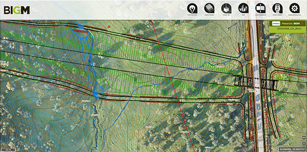
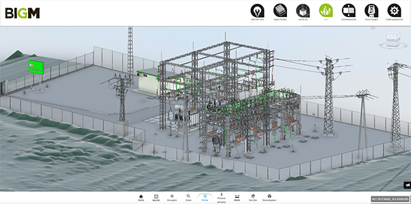
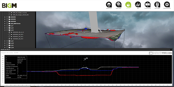
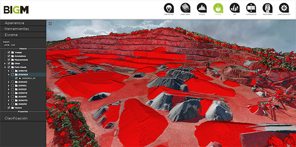
Digital Twin
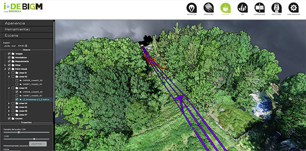
3D Digital Twin - DTM, high-quality orthophotos, point clouds obtained with drones, LiDAR, etc., project information, layout, alignment status, stockpile areas, etc
3D Information
Information from drones, airplanes, satellites, aerial LiDAR, terrestrial LiDAR, Mobile Mapping, GPS, Total Stations, etc. Design of custom algorithms to handle information via the Web, with the same resolution and unprecedented speed
Historical reconstruction and temporal comparators for precise analysis
BIGMonitor allows historical reconstructions and temporal comparisons to study the evolution of a project or any analyzed element. Through tracking at different points in time, it is possible to visualize changes, identify trends, and assess progress accurately. Additionally, the system generates automatic reports on earth-moving activities, providing detailed data on displaced volumes, operational efficiency, and schedule compliance. All of this is in real-time and with the precision of Artificial Intelligence, facilitating informed decision-making and optimizing project management
Incorporation of AI for work progress calculation
BIGMonitor integrates Artificial Intelligence to optimize the calculation of work progress, associating geospatial and production data with intelligent databases. This technology enables the generation of control and tracking charts, facilitating the analysis of project evolution in real time. Through direct connections with databases, the system extracts economic and progress information, allowing precise control of costs and timelines. Additionally, the automation of reports provides a clear and detailed view of the project's status, speeding up decision-making and improving operational efficiency
Integration of IoT and artificial intelligence for geospatial data analysis
BIGMonitor integrates IoT sensors and artificial intelligence technology to process and analyze geospatial data in real time. Through its integration with specialized databases, it enables the automatic generation of structural control charts, providing key information on foundations, wind turbines, hotspots in electrical lines, project progress, and infrastructure monitoring.Thanks to its advanced calculation capabilities, the system performs real-time measurements of volumes, displacements, areas, and distances, optimizing the supervision of earthworks and the management of engineering projects. Additionally, it allows for the automatic creation of detailed reports, facilitating decision-making and improving operational efficiency
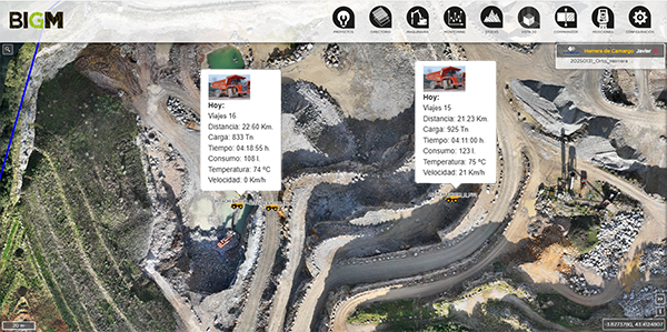
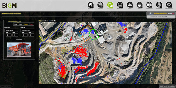
Real-time monitoring of machinery production
BIGMonitor offers a comprehensive solution for project and mining control, allowing real-time monitoring of machinery production. The platform provides detailed information on transported material, weight, fuel consumption, and route optimization, facilitating efficient resource management and improving project productivity.Thanks to its integration with IoT sensors and databases, BIGMonitor enables precise analysis of machinery performance, helping to reduce operational costs, minimize downtime, and maximize efficiency in project execution and mining operations
BIM model in IFC or RVT format in the project
Incorporation of BIM models in standard IFC or RVT formats in the project, including Autodesk Revit models and other compatible formats
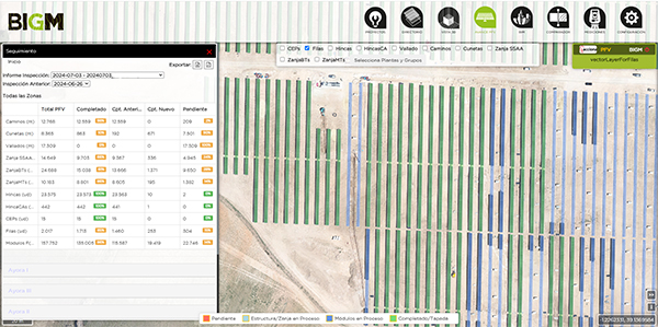
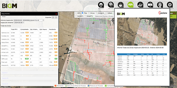
Construction Monitoring of Photovoltaic and Wind Farms
With BIGMonitor, the use of digital twins and drones truly transforms the way we manage these projects. Artificial intelligence allows for a detailed analysis of the data, making it easier to compare with the original plans. This way, you can know in real-time how many piles, photovoltaic modules, meters of trench, or roads have been completed and how many are left to finish. Additionally, having the report instantly available in PDF and Excel formats is a great advantage for keeping everything organized and accessible
CONSTRUCTION MONITORING AND CONTROL (CE-BIGM)
Imagine having an online application that allows you to visually and analytically compare, interactively and easily, the control and monitoring data of projects. Instead of reviewing data lists, you will be able to explore and inspect the project from an overview down to the finest detail. Interact with each component through real images and videos integrated into the project, and obtain the necessary charts for effective analysis and monitoring. All of this remotely, from any device (smartphone, tablet, PC, etc.) with an internet connection
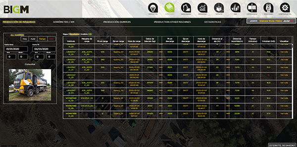
Daily tables and charts showing the production of trucks, bulldozers, loaders, and others
Control of production in m³ or tons per PK or branch, kilometers traveled, effective working time, consumption, etc. All of this is exportable to Excel or can be automatically sent by email every day, providing an up-to-date record of each machine's earthmoving activities in real time
Real-time monitoring of machinery production
With BIGMonitor, we have real-time data on machinery production on-site, including transported material, weight, consumption, route optimization, among others. If a machine’s production does not meet the required levels, exits the work zone, exceeds the allowed speed, or presents any anomaly, an alert will be triggered, immediately notifying the supervisor
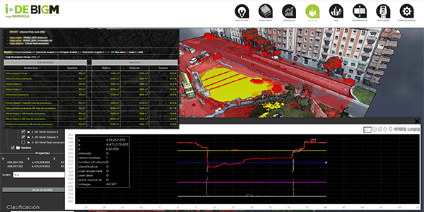
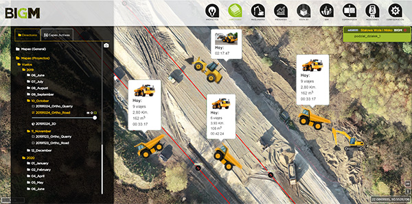
Daily, weekly, or monthly tables and charts detailing earthmoving activities using drones
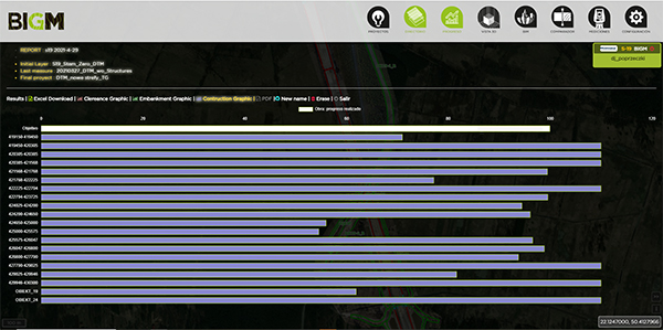
At the start of the project, the different work units, the original terrain DTM, and the final state of the project once completed are entered. With these initial values and the digital twins obtained through drones, BIGMonitor calculates the earthmoving for each work unit in a matter of seconds. The results are exported to Excel or PDF, accompanied by intuitive charts that detail the excavation or embankment for each unit, showing the cubic meters moved to date and the remaining volumes to complete each unit
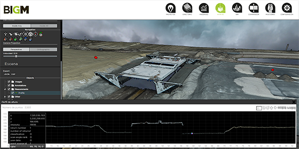
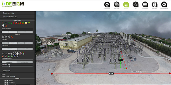
3D Project Monitoring
It is no longer necessary to visit the site as frequently to understand the details of each aspect. With digital twins, you can access all the information, calculate and verify the different layers of pavement, among other aspects, remotely
TEMPORAL CONTROL OF ACTIONS
The temporal analysis of digital twins will allow you to review the affected area before starting the work, monitor its evolution during execution, and compare the final result with the execution project. The information is updated through drone flights, with the frequency you choose: weekly, monthly, quarterly, or annually. By interacting with the elements of the project (structures, drainage, trenches, tunnels, etc.), you can access detailed information about each one: plans, photographs, videos, progress status, and much more, with just one click
SECURE AND ACCESSIBLE FROM ANYWHERE
BIGMonitor is configured with specific access profiles and passwords, ensuring encrypted access for project agents from anywhere, at any time. It allows you to compare the monitoring of production, costs, and the Work Plan in a graphical or analytical format, either instantly or over time. Additionally, you can integrate the control and monitoring plans for the project, organize reports on the identification of material and equipment sources, manage manufacturer certification and quality documents, or verify the correspondence with the supplied materials and equipment. All elements that require execution control and validation are integrated into the monitoring, enabling you to manage and make decisions quickly and in a coordinated manner
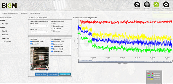
MONITORING (AUS-BIGM)
The construction of large engineering projects requires thorough and analytical control during its execution, especially when it involves projects that can affect people and property in their area of influence. The frequent accidents that have occurred in recent years highlight the importance of continuous monitoring, capable of detecting any significant deformation in time. This control allows for anticipating problems that could have serious economic and personal consequences, facilitating the necessary corrections to avoid or minimize undesired effects
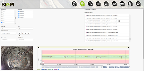
Everything under control with predictive and real-time alarms
With BIGM, you can maintain control of any asset, whether it's a tunnel, building, slope, landfill, or unstable area. Predictive alarms will give personnel the necessary warning to evacuate the affected area on time. Additionally, you will have a detailed history of movements, allowing you to analyze the actions taken on each element
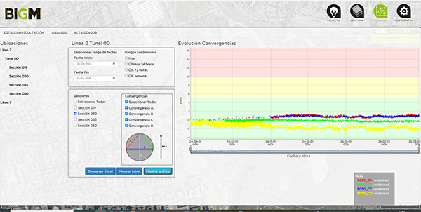
Automated Surveying with Senceive Sensors for monitoring unstable areas, tunnels, buildings, or landfills
All sensors installed by BIGMonitor are fully automated, ensuring that their operation does not interfere in any way with the progress of the activity
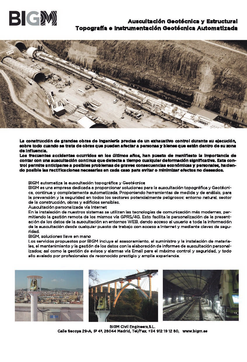
BIGM AUTOMATES SURVEYING AND GEOTECHNICAL MONITORING.
BIGM is a company specialized in providing automated solutions for surveying and geotechnical monitoring. It offers measurement and analysis tools aimed at prevention and safety in potentially hazardous sectors, such as the natural environment, construction, and projects involving sensitive or affected buildings
CUSTOMIZED MONITORING VIA INTERNET
Our systems use the most advanced communication technologies, allowing remote management through 5G telephony, fixed connections, WIFI, or radio solutions. This facilitates the customization of the presentation of monitoring data in web environments, providing the user with full access to information from any workstation with internet access and through security keys
BIGM, TURNKEY SOLUTIONS
The services offered by BIGM include: consulting, supply and installation of materials; maintenance and data management with the creation of customized monitoring reports; management of alerts and alarms via email to ensure maximum control and safety. All of this is supported by highly respected professionals with extensive experience
Case study
RENEWABLE ENERGY (ENE-BIGM)
BIGM offers detailed tracking of work units for renewable energy or Gas & Oil projects. Along with the surveying team on-site, equipped with the most advanced technology, including state-of-the-art drones, we perform both quantitative and qualitative monitoring of the project. Thanks to BIGMonitor, you can conduct thorough tracking of the progress in the installation of wind, photovoltaic, or biomass parks, as well as carry out control and monitoring of linear assets such as power lines, oil pipelines, and gas pipelines
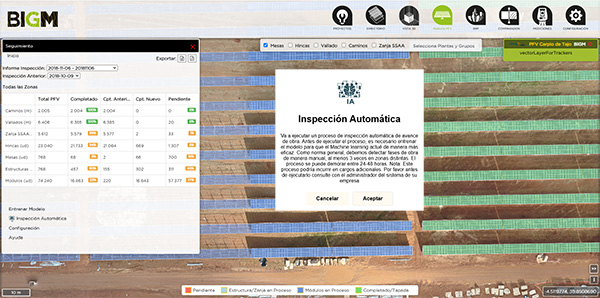
Quantitative analysis of the photovoltaic park construction
With BIGMonitor, you will have full control over the construction of the photovoltaic park. By entering initial parameters, such as the location of the piles, dimensions of the photovoltaic modules, roads, trenches, fencing, among others, you will know, thanks to artificial intelligence analysis, how many elements have been completed and how many are left to finish. Additionally, it will generate a report in PDF or Excel format in just 2 seconds with a single click
Automatic report generated seconds after the progress analysis
Instant generation of reports in PDF and Excel format, providing a detailed and accurate summary of the project's progress in a matter of seconds
Control of the wind turbine foundations
You will be able to verify that the excavation and the cage with the structure are perfectly positioned. The traceability of the process is complete, ensuring detailed and precise monitoring at every stage
Control of roads, trenches, and wind turbine foundations
Detailed supervision of all elements, ensuring quality and traceability at every stage of the process, guaranteeing a complete record for any potential future claims
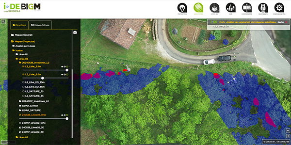
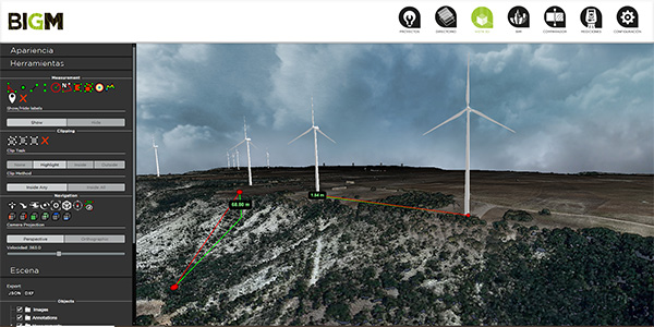
Power Lines and encroachment control
Supervision of constructions and vegetation growth within the right-of-way or street. Thanks to artificial intelligence and the digital twin obtained with LiDAR, whether mounted on drones or helicopters, the system will automatically detect areas that require pruning or special actions in case of interference with constructions
Power Lines and 3D encroachment control
2D or 3D visualization. The system, thanks to artificial intelligence and the digital twin generated with LiDAR mounted on drones or helicopters, will automatically detect areas that need to be pruned or where special actions should be taken due to interference with constructions
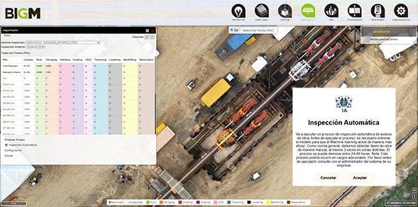
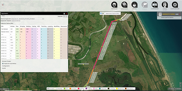
Monitoring the construction of Gas & Oil pipelines
Thanks to the digital twin generated with drones or satellites, you will have full control over the pipeline construction. By entering initial parameters, such as the alignment status of the pipeline, BIGMonitor and its artificial intelligence analysis will allow you to know the phase of each PK (kilometer point) of the pipeline
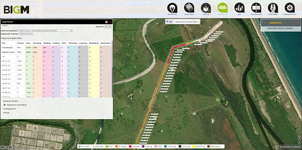
Monitoring the construction of Gas & Oil pipelines.
With the digital twin obtained through drones or satellites, you will have full control over the pipeline construction. By entering initial parameters, such as the alignment status of the pipeline, BIGMonitor and its artificial intelligence analysis will allow you to know the phase of the pipeline at each PK (kilometer point). The report, in PDF or Excel format, will be available in just 2 seconds with a single click
INSPECTION OF ELECTRICAL LINES OR OPERATING PIPELINES
The system, thanks to artificial intelligence and the digital twin obtained with LiDAR mounted on drones or helicopters, will automatically detect areas that require pruning, special actions in constructions, or potential leaks in the case of pipelines
MINING (MIN-BIGM)
With BIGMonitor’s solution, from your own flights or those of your usual provider, you will receive a PDF or Excel report with all your assets perfectly inventoried. Additionally, if the control you need requires real-time monitoring of production, simply installing a GPS sensor on the machinery will allow you to obtain this data instantly
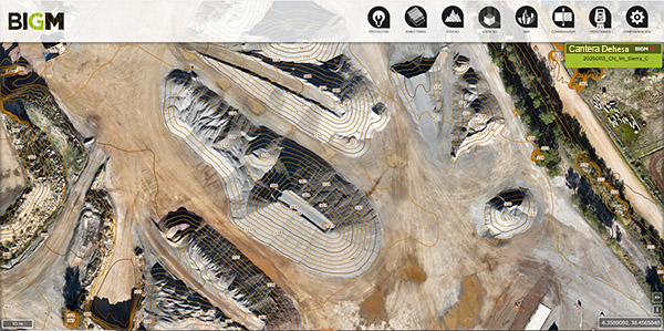
Mining and QuarrieS
With the drone flights you conduct yourself, at the frequency you desire, you will have your stockpiles perfectly inventoried. Additionally, you will be able to access the 2D and 3D history with just one click, allowing you to compare measurements over different periods of time
Mining and Quarries. All the history with a click
With the drone flights you conduct yourself, at the frequency you need, you will have your stockpiles fully inventoried. Additionally, you will have quick access to the history in 2D and 3D, allowing you to compare measurements over different time periods
Production and stock in real time with the GPS tracking system
With this system, you will be able to know the stock data in real time. You can reassign machine tasks based on the type of material that needs to be produced. Additionally, you will have visibility of the trips and the material transported by the trucks, whether to the primary area or to the warehouses, automatically tagging the type of material
Production and stock in real time with the GPS tracking system
We will have an Excel list of the machine production sheet, keeping the stock updated. Downloads will be highlighted in blue, mainly in the primary or waste area, and the loads in red, in the extraction zones
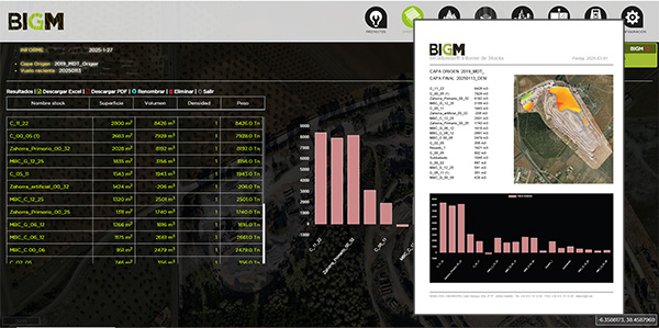
Automatic stock calculation and report in PDF or Excel
We label the stockpiles and, referencing the original terrain, calculate all the stockpiles in seconds. The report is generated automatically, saving time and effort in the process
CONTACT
SIf you need more information about BIGM or our services, please don’t hesitate to contact us today. You can reach us via email, call us, or visit us at our offices. We will be happy to assist you
HEADQUARTERS
Secoya 29A 4º 5ª
28044 Madrid
España
tef. +34 912 191 280
info@bigm.es
TOPOFOR
LG O Pazo Mourente, 23, 36164
Pontevedra
tel. 986 86 21 15 – 657 19 69 60
SERVICIOS TECNICOS TOPOGRAFICOS
Jesús Ferrer Jimeno, 13, Local 54, 35010,
Las Palmas de Gran Canaria (LAS PALMAS)
tel. 928 272 257
COINPRO Martenu International, S. de R.L. de C.V.
Manuel González No. 50B 206 Nonoalco Tlatelolco, alcaldía Cuauhtemoc, Ciudad de México
México
https://www.coinpromex.com/
proyectos@coinpromex.com
tef. +52 5641 701973
+52 5641701978
AEROCAM
Ctra Panam. Sur km.37
Lurín, Lima. Perú
PERÚ
tel. +51 933 602 674
info@aerocamservicios.com
Yema Consulting
ul. Łazienkowska 14, piętro I, lok.5
bud. Łazienkowska Castle
00-449 Varsovia
Polonia
tel. +48 601-199-811
Leica Geosystems
Urb. Jardins do Cristo Rei, Av. Capitão Salgueiro Maia, 10B - Lj 2, 1885-076 Moscavide
Portugal
tel. +351 21 448 0930
SÍGUENOS